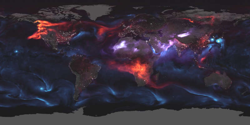
Credit & Copyright: NASA Earth Observatory,
GEOS FP,
Joshua Stevens
Explanation:
On August 23, 2018
the identification and distribution of
aerosols
in the Earth's atmosphere is shown in this dramatic,
planet-wide visualization.
Produced in real time, the Goddard Earth Observing System Forward
Processing (GEOS FP)
model relies on a combination of
Earth-observing satellite and
ground-based data to calculate the presence of types of aerosols,
tiny solid particles
and liquid droplets, as they circulate above the entire planet.
This August 23rd model shows black carbon particles in red
from combustion processes,
like smoke from the fires in the United States and Canada,
spreading across large stretches of North America and Africa.
Sea salt aerosols are in blue, swirling above threatening typhoons near
South Korea and Japan, and the hurricane looming near Hawaii.
Dust shown in purple hues is blowing over African and Asian deserts.
The location of cities and towns can be found from the
concentrations of lights based on satellite image data of
the Earth at night.
1999 2000 2001 2002 2003 2004 2005 2006 2007 2008 2009 2010 2011 2012 2013 2014 2015 2016 2017 2018 2019 2020 2021 2022 2023 2024 2025 |
Январь Февраль Март Апрель Май Июнь Июль Август Сентябрь Октябрь Ноябрь Декабрь |
NASA Web Site Statements, Warnings, and Disclaimers
NASA Official: Jay Norris. Specific rights apply.
A service of: LHEA at NASA / GSFC
& Michigan Tech. U.
|
Публикации с ключевыми словами:
Earth - Earth's atmosphere - Земля - атмосфера Земли
Публикации со словами: Earth - Earth's atmosphere - Земля - атмосфера Земли | |
См. также:
Все публикации на ту же тему >> | |
