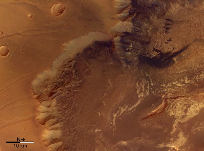
Explanation: Steep cliffs drop into the rugged terrain of Melas Chasma in this stunning view from the Mars Express spacecraft orbiting the Red Planet. At a scale of 16 meters per pixel, the image data from the orbiter's High Resolution Stereo Camera offers evidence that volcanic activity, water, wind erosion and marsquakes may all have shaped the region. Melas Chasma lies along the central southern edge of the large Valles Marineris, the grand canyon of Mars. While the Valles Marineris is itself over 4,000 kilometers long and up to 10 kilometers deep, the region pictured spans about 70 kilometers. The floor of Melas Chasma seen here is several kilometers below the surrounding plateau.
1999 2000 2001 2002 2003 2004 2005 2006 2007 2008 2009 2010 2011 2012 2013 2014 2015 2016 2017 2018 2019 2020 2021 2022 2023 2024 2025 |
Январь Февраль Март Апрель Май Июнь Июль Август Сентябрь Октябрь Ноябрь Декабрь |
NASA Web Site Statements, Warnings, and Disclaimers
NASA Official: Jay Norris. Specific rights apply.
A service of: LHEA at NASA / GSFC
& Michigan Tech. U.
|
Публикации с ключевыми словами:
Melas Chasma - mariner valley - Mars - Mars-Express - Марс - поверхность Марса - долина
Публикации со словами: Melas Chasma - mariner valley - Mars - Mars-Express - Марс - поверхность Марса - долина | |
См. также:
Все публикации на ту же тему >> | |
