Credit & Copyright: R. Irwin III
(CEPS/NASM,UVa),
T. Maxwell,
A. Howard,
R. Craddock,
D. Leverington
Explanation:
Just as erosion from the Colorado River carved
the Grand Canyon
on Earth, a river of flood water may have carved Ma'adim Vallis,
one of the largest canyons
on Mars.
Researchers have
presented strong evidence for such
a
scenario based on elevation data recorded by the
MOLA
(Mars Orbiter Laser
Altimeter) experiment on the
Mars Global Surveyor spacecraft.
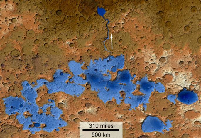
This false-color, detailed,
topographical map of MOLA data
shows in blue the area of an enormous complex
of
lakes that are thought to have existed
over three and a half billion years ago
in the southern highlands of Mars.
As the largest lake spilled over the low point in its boundary
a torrential flood would have moved north, along the direction
indicated by the arrow, carving the sinuous Ma'adim Vallis.
At the north end of Ma'adim Vallis, the flood waters would
have poured into
large,
round Gusev Crater.
Since standing bodies of surface water are thought to be
favorable for ancient
martian microbial life, Gusev Crater
has been suggested as a landing site for
future Mars missions.
1999 2000 2001 2002 2003 2004 2005 2006 2007 2008 2009 2010 2011 2012 2013 2014 2015 2016 2017 2018 2019 2020 2021 2022 2023 2024 2025 |
Январь Февраль Март Апрель Май Июнь Июль Август Сентябрь Октябрь Ноябрь Декабрь |
NASA Web Site Statements, Warnings, and Disclaimers
NASA Official: Jay Norris. Specific rights apply.
A service of: LHEA at NASA / GSFC
& Michigan Tech. U.
|
Публикации с ключевыми словами:
Mars - crater - water - Марс - жизнь на Марсе
Публикации со словами: Mars - crater - water - Марс - жизнь на Марсе | |
См. также:
Все публикации на ту же тему >> | |
